ပြည်ထောင်စုသမ္မတမြန်မာနိုင်ငံတော်အစိုးရ
သယံဇာတနှင့်သဘာဝပတ်ဝန်းကျင်ထိန်းသိမ်းရေးဝန်ကြီးဌာန
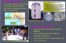
မြေတိုင်းဦးစီးဌာန
တိကျမှန်ကန်မြေတိုင်း“စံ”

 မြန်မာဘာသာ
 Mapping
Topographic Maps that have been used since pre World War II time were based on Lambert Conical Projection. Myanmar is a State where extent of North- South direction is larger than that of East-West direction. In such condition,...
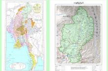
Survey Department Produces the following maps.
(a) UTM Map ( 1:50,000 Scale )
(b) UTM Map ( 1:100,000 Scale )
(c) UTM Map ( 1:250,00...
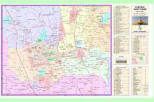
All the topographic maps published by the Survey Department can only be available with the permission of Ministry of Defence. However, Maps of Myanmar and maps of State/Region are publicly available.
