ပြည်ထောင်စုသမ္မတမြန်မာနိုင်ငံတော်အစိုးရ
သယံဇာတနှင့်သဘာဝပတ်ဝန်းကျင်ထိန်းသိမ်းရေးဝန်ကြီးဌာန
မြေတိုင်းဦးစီးဌာန
တိကျမှန်ကန်မြေတိုင်း“စံ”

 မြန်မာဘာသာ
 Geodetic and No.(2) Survey Division
Geodetic and No. 2 Survey Division
Background
The survey of India had taken responsibilities of surveying and reproduction of maps in Myanmar up to the end of World War II. In 1st November 1946, Myanmar Survey Department was formed with a view to assumption of surveying and mapping in the country. Under the Department, No.(2) survey party and Geodetic and research survey party were formed in 1957 and 1958 respectively.
Officer in charge U E Thwin was firstly in charge of the No.(2) Survey Party and officer in charge U R. Hla Kyaw was firstly in charge of the Geodetic and Research Survey Party before U Sein Lwin till 1959.
Each Survey Parties located at No.460, Merchant Street, Botahtaung Township within 1957-58 and 1971-72. And then located at Pyidawaye avenue lane, World Peace Pagoda Road, Yankin Township within 1971-72 and 2011. Currently, they located at circular road, Ottrathiri Township, Naypyidaw.
Individually standing No(2) Survey Party and Geodetic and Research Survey Party were naming No.(2) Survey Sub Division and Geodetic Survey Sub Division and also combined to Geodetic and No.(2) Survey Division according to the new organization set up which has been formed in beginning of year 1990.
Geodetic and No.(2) Survey Division is under the management of a Director and such like the Survey Department, this division situate under the Ministry of Environmental Conservation and Forestry.
List of the Supremes who were in charge of the Geodetic and No.(2) Survey Division from 1990 in after years.
|
Sr |
Name |
Designation |
Duration |
Remarks |
|
1. |
U Than Myint |
Director |
From 1991 to 1994 |
|
|
2. |
U Aung Than |
Director |
From 1994 to 1996 |
|
|
3. |
U Tin Myint |
Director |
From 1996 to 2001 |
|
|
4. |
U Nyi Htoo |
Director |
From 2001 to 2002 |
|
|
5. |
U Min Sein Lwin |
Director |
From 2002 to 2003 |
|
|
6. |
U Myo San |
Director |
From 2004 to 2010 |
|
|
7. |
U Saw Hla Naing |
Director |
From 2010 to 2012 |
|
|
8. |
U Hla Khaing |
Director |
From 2012 to 2013 |
|
|
9. |
U Thet Oo |
Director |
2013 |
|
|
10. |
U Thein Naing |
Director |
From 2013 to 2015 |
|
| 11. | U Thet Oo | Director | From 2015 to 2016 | |
| 12. | U Aung Moe | Director | From 2016 to till today |
Organizational Structure and Manpower
The organizational structure and strength of staff capacity at the end of March, 2024 are as follow.
Organizational Structure

Manpower
|
|
Strength |
Posted |
Vacancy |
|
Officers Other Ranks |
16 245 |
13 54 |
3 191 |
|
Total |
261 |
67 |
194 |
Objectives
Geodetic and No.(2) Survey Division carried out his tasks according to the following objectives.
(1) To undertake the precise ground surveying to produce topographical maps of
various scales for military purpose and for social, economic and administrative
works while the used units and systems being changed from British system to
metric system.
(2) To undertake the UTM Maps verification tasks for UTM Maps (up date) Revision
works to get accuracy to the 1:50000 Scale, 1:100000 Scale, 1:250000 Scale
UTM Maps already published all over the country.
(3) To construct the Bench Marks and conduct first order leveling on them all over
the country.
(4) To construct the growth Ground contort point (GCP) and conduct GPS observation
and second order leveling on them.
(5) To make inspection and maintenance of GCPs and BMs.
(6) To conduct the GPS observation and Total Station observation for project maps
on demand.
(7) To take part in demarcation of the international Boundaries of the adjacent
Countries around the Myanmar as and when necessary.
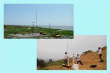
Tasks of Geodetic and No. 2 Survey Division
Worked out Tasks
Worked out tasks from 2011-2012 Financial year till today are as follow;
2011-2012
-Carried out the field verification of 142 UTM Maps which miss on ground.
-Carry out the GPS observation about 202.51 square kilometer area of Dawei Special
Econoic Zone, Tanintharyi Region.
-Carried out the GPS observation and third order leveling of 68 GCPs in Ayeyarwady,
Yangon and Bago Regions.
-Carried out the first order leveling on 40 BMs ( 120 Miles distance) from Min pya
to Sittwe, Rakhine State.
-Carried out the field surveying of Thilawa Special Economical Zone Area.
-Carried out the field surveying for region overlapping bourndarys between Gangaw
(Maagawe)- Hakha(Chin) and Myingyan(Mandalay)-Pakoku (Magwe).
2012-2013
-Carried out the field verification of 170 UTM Maps for UTM Maps (up date) Revision.
-Carried out the first order leveling and construction of 80 BMs(160 miles distance)
along the Yangon-Napyitaw High-way.
-Carried out the GPS observation and third order leveling of 50 GCPs in Bago and
Mandalay Region.
-Carried out the field verification of large scale map for Yangon and downtown areas.
2013 -2014
-Carried out the GPS observation and third order leveling of (50) GCPs in Magwe
Region
-Carried out the field verification of 150 – UTM maps for UTM Map ( update) Revision
in Magwe, Mandalay, Sagaing and Tanintharyi Regions.
-Carried out the GPS observation and third order leveling of 9- GCPs for aerial
photograph in mid country area by means of digital aerial camera
-Carried out the ground surveying about 5931.371 acres of Htiki Border Industrial Free
Zone Area, Tanintharyi Region
-Carried out the GPS observation and third order leveling of 13 – GCPs for pilot project
at Aung Hlaing village, Laputta District, Ayeyarwady Region cooperate with Thailand
base regional integrated Multi-Hazard Early Warning System (RIMES)
-Carried out the GPS observation and third order leveling of 13 – Airbone GPS ground
base stations for Aerial Photograph in Delta Region
-Carried out the first order leveling and construction of 80- BMs ( 160 miles distance)
along the Naypyidaw – Mandalay High way.
2014-2015
-Carried out the field verification of 1:50000 scale UTM Map (150) sheets for (Update)
Revision in Magway Region, Chin State, Sagaing Region, Mandalay Region, Shan State
and Bago Region.
-Carried out the GPS observation and leveling of (35) GCPs in Southern Shan State.
-Carried out GPS observation and leveling of (9) GBS and (18) GCPs for Aerial Photography
in Bago Region, Lower Part of Magway Region, Upper Part of Ayeyawady Region, Kayin State
and Rakhine State areas.
-Carried out the first order leveling and construction of (78) BMs along the leveling line between
Mandalay and Kawlin.
2015-2016
-Carried out the field verification of 1:50000 scale UTM Map (75) sheets for (Update) Revision in
Rakhine State and Chin State.
-Carried out the GPS observation and leveling of (35) GCPs in Southern Sagaing Region.
-Carried out the Boundary Demarcation of Thilawa Special Economic Zone about 1345.644 acres.
Future Plan
Geodetic and No.(2) Survey Division has to perform the following tasks as forward functions.
-To conduct the maps verification task for UTM maps (update) revsion works to get
accuracy to the 1:50000 scale , 1:100000 scale and 1:250000 scale UTM Maps already
published all over the country.
-To construct the Bench Marks and conduct first order levling on them
-To construct the growth Ground Control Point (GCP) and conduct GPS observation and
second order leveling on them.
-To conduct the GPS observation and Total Station observation for project maps on
demand
-To take part in demarcation of the international boundaries of the adjacent countries
around the Myanmar as and when necessary
-To distribute the survey subject lectures and manipulation of Height Tech Instruments.
-To investigate on modern technique and making research in all branches of Survey.
Instruments, Hardware and Software
Instruments used in Geodetic and No.(2) Survey Division
|
sr |
Description |
Model |
Capiticy |
Software |
Quantity |
Remarks |
|
1. |
Nikon Total Station |
NIVO-1-C, Japan |
Detail surveying |
Auto cad |
2 |
|
|
2. |
Trimble Total Station |
M-3 ( 1") , USA |
Detail surveying |
T.B.C version 2.95 |
1 |
|
|
3. |
Trimble Total Station |
M-3 ( 1") , USA |
Detail surveying |
T.B.C version 2.95 |
2 |
|
|
4. |
Trimble Digital Level |
Dini Japan |
Leveling |
T.B.C version 2.95 |
2 |
|
|
5. |
Trimble GPS & controller |
5800,TSC-2,USA |
Static/RTK |
T.B.C version 2.95 |
3 |
|
|
6. |
Trimble GPS & controller |
R-10-GNSS,TSC-3 ,USA |
Static/RTK |
T.B.C version 2.95 |
3 |
|